


وصف لـ Hiking Project
Hiking Project is your comprehensive guide to the best hikes near you, wherever you are.
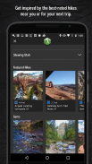
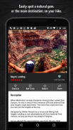
With the thoroughness of a printed map, we offer full GPS route info, elevation profiles, interactive features, photos, and more. Like a guidebook, we suggest the best featured hikes to explore—either near your current location or in an area you search for. Local experts show you the highlights, challenging features, and insights you need to plan a great day on the trails.
• Find over 74,000 miles of trail to hike with your crew.
• New trails are constantly added to our incredibly detailed hiking database.
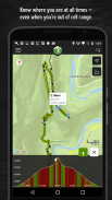
• Your exact location is shown on the trail.
• Downloaded trails work offline for when you’re off the grid. (No cell reception required!)
• Enjoy high-resolution photos and detailed topographical trail maps.
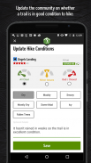
• We’ll sync with your to-do list and check ins on HikingProject.com.
By using GPS, we can show your location on trails and vertical profiles. Continued use of GPS running in the background can dramatically decrease battery life.
Links:
• Privacy Policy: http://www.mountainproject.com/scripts/PrivacyPolicy.php
• When you download or use an REI app, we collect information about you as described in our privacy policy: https://help.rei.com/app/answers/detail/a_id/50#Your_California_Privacy_Rights.
• Terms of Service: http://www.mountainproject.com/scripts/TermsOfUse.php
مشروع التنزه هو دليلك الشامل لأفضل المشي بالقرب منك أينما كنت.
من خلال دقة الخريطة المطبوعة ، نقدم معلومات كاملة عن مسار نظام تحديد المواقع العالمي (GPS) ، وملفات تعريف الارتفاع ، والميزات التفاعلية ، والصور ، والمزيد. مثل الدليل ، نقترح أفضل الرحلات المميزة لاستكشافها - إما بالقرب من موقعك الحالي أو في منطقة تبحث عنها. يُظهر لك الخبراء المحليون أهم الميزات والميزات الصعبة والرؤى التي تحتاجها للتخطيط ليوم رائع على المسارات.
• ابحث عن أكثر من 74000 ميل من المسار للتنزه مع طاقمك.
• تتم إضافة مسارات جديدة باستمرار إلى قاعدة بيانات المشي لمسافات طويلة المفصلة بشكل لا يصدق.
• يظهر موقعك الدقيق على درب.
• تعمل الممرات التي تم تنزيلها بلا إنترنت عندما تكون خارج الشبكة. (لا يلزم استقبال خلية!)
• استمتع بصور عالية الدقة وخرائط طوبوغرافية تفصيلية.
• سنقوم بالمزامنة مع قائمة المهام الخاصة بك والتحقق من معلومات على HikingProject.com.
باستخدام GPS ، يمكننا عرض موقعك على الممرات والملفات الرأسية. يمكن أن يؤدي استمرار استخدام GPS قيد التشغيل في الخلفية إلى تقليل عمر البطارية بشكل كبير.
الروابط:
• سياسة الخصوصية: http://www.mountainproject.com/scripts/PrivacyPolicy.php
• عند تنزيل تطبيق REI أو استخدامه ، نجمع معلومات عنك كما هو موضح في سياسة الخصوصية الخاصة بنا: https://help.rei.com/app/answers/detail/a_id/50#Your_California_Privacy_Rights.
• شروط الخدمة: http://www.mountainproject.com/scripts/TermsOfUse.php
Hiking Project - معلومات APK
نُسخة APK: 24.9.0الحزمة: com.hikingproject.androidتطبيقات من الفئة نفسها
قد يعجبك أيضًا...


